Bay Area weather: How much rain did we get?
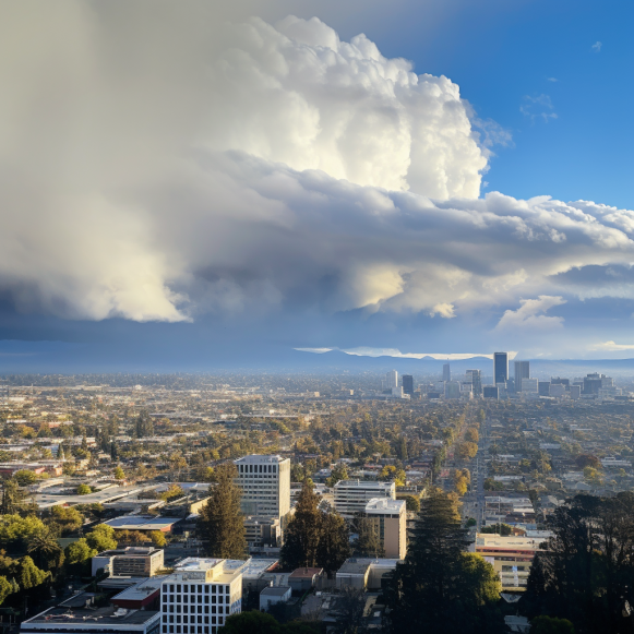
Sunday was the wettest day in the Bay Area in nearly six months
It wasn’t a torrential downpour. It wasn’t just a light sprinkle, though. And a few areas in the mountains actually received a good amount.
The rain that fell across the Bay Area on Sunday was the most precipitation for any day in nearly six months.
That is not uncommon. Most summers in California see very little rain. Nonetheless, the rainy Sunday served as a reminder that autumn has arrived and that the state’s winter rainy season has begun.
San Francisco received.19 inches of rain on Sunday, which isn’t much by winter storm standards. The city last received more rain in a single day on May 5, when it received.54 inches.
.19 inches fell in Oakland, the most since May 6, when.22 inches fell.
Because the storm made landfall primarily in Sonoma County, rain totals were lower further south. San Jose received.07 inches of rain on Sunday, slightly less than the.08 inches that fell on September 30. The last time the Bay Area’s most populous city received significantly more rain was on May 5, when.15 inches fell.
A few higher elevations received significant rainfall, with 2.34 inches falling on Mount Tamalpais in Marin County and 1 inch falling in the Santa Cruz Mountains and East Bay Hills.
“This is the kind of rain we like to see,” said Dalton Behringer, a National Weather Service meteorologist in Monterey. “There wasn’t any flooding.” But it was enough to wet the ground, as well as the trees and grass, reducing the risk of a fire.”
After a few dry and cooler days, the next chance for rain is Thursday night, according to Behringer. This will most likely be less than Sunday’s and will be more focused on the North Bay. Otherwise, the rest of the month, including Halloween, looks dry.
Last winter, more than 30 atmospheric river storms filled reservoirs across California and dumped the most snow in the Sierra Nevada in 40 years, bringing the state’s severe three-year drought to an end. Rainfall totals in the Bay Area were also high.
San Francisco received 33.87 inches — 148% of normal — during the 2022-23 “water year” that ended on September 30. It was the 14th wettest year in the 174 years since records began in 1849, and the wettest since 1997-98, when 46.56 inches fell during a soaking El Nio winter that caused widespread flooding throughout the state.
Strong El Nio conditions are developing in the Pacific Ocean, with warmer-than-normal ocean temperatures along the equator off the coast of South America. Although El Nio conditions increase the likelihood of a wet winter in Southern California, they are not a guarantee of a wet winter in the Bay Area or other Northern California areas.
“It’s a tossup,” Behringer said. “If you look back at El Nio years, you’ll see severe droughts and extremely wet years.” The signal strength is low.”
So far in October, rainfall totals have been mediocre. Despite the fact that far Northern California is off to a wet start, with Eureka at 138% of its historical October average, Santa Rosa was at 63% of normal for the month, and San Francisco and San Jose were at 33%. In October, there has been no rain in Los Angeles.
“We are below normal,” said Behringer. “But it’s October and we are just starting the winter season.”