Users beware: Trail apps have been leading to problems in public lands
Government agencies meeting with AllTrails and others to sort out long-standing issues
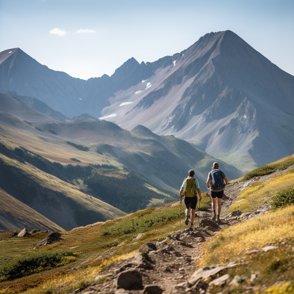
Last week, veteran mountaineer Dale Atkins was climbing the difficult Kelso Ridge on Torreys Peak, a popular 14,000-foot peak in Colorado, when he met a woman in her 20s who had discovered the complexity of the climb required route-finding skills beyond her experience level.
“She said she’d gotten to one of the harder spots and just couldn’t figure out where to go, so she turned around,” said Atkins, a member of the Alpine Rescue Team, a volunteer search-and-rescue organization that operates in Clear Creek, Jefferson, and Gilpin counties.
“I asked her if she was using an app, and she said, ‘Yes, AllTrails,'” he continued. “She said all the reviews were really positive about the climb, so she figured she could do it with three fourteeners under her belt.” Her ambitions simply outweighed her experience.”
Atkins was not taken aback. Many Colorado hikers rely on the popular hiking app, which includes digital trail maps and user-generated reviews. However, it lacks detail in describing difficult climbs such as the Kelso Ridge, which can be seen from Interstate 70 five miles west of Silver Plume. He and the Alpine Rescue Team had previously responded to other climbers who had become stuck on the route while using trail apps and needed to be guided out.
The shortcomings of crowdsourced apps like AllTrails and Gaia GPS, which show where trails are on digital maps and provide user-generated feedback and reviews, but leave hikers wanting for specific route details, are being discovered by public land managers across the country. There are other issues, such as leading hikers to closed trails or crossing private land.
In fact, it has become such a concern that government agencies such as the National Park Service, the United States Forest Service, and the Bureau of Land Management have been meeting with these companies and others twice a month for the past two years to discuss solutions.
“It’s an issue that we’ve been dealing with in the forest service for a little while now, trying to better understand how we can address it,” said Chad Schneckenburger, USFS Rocky Mountain Region trails manager. “It’s really a management challenge for us.” All of those apps have been crowdsourced. It is essentially user-generated data.”
According to Atkins, the problem on trails like Kelso Ridge is that users, particularly inexperienced hikers, do not understand the limitations of the apps.
“It’s not an AllTrails issue per se,” he explained. “Even if she had a regular topo map, it would have told her where to go but not how to get through the terrain.” The limitations aren’t necessarily with the apps, but with people’s ability to perceive the terrain around them.”
Maggie Cawley, the executive director of OpenStreetMap US, the U.S. chapter of an international nonprofit that is a primary source for AllTrails and other apps, led the working group formed to improve the data behind trail apps. OpenStreetMap, which is based on crowdsourced data, is sometimes referred to as the Wikipedia of maps.
Keri Nelson, then a National Park Service backcountry coordinator for southeast Utah, contacted Cawley two years ago to report problems caused by trail apps in Canyonlands National Park near Moab. Cawley asked Nelson to give a presentation at an OpenStreetMap US-hosted virtual meeting of the mapping community.
“What we were seeing in the park was people adding trails or trail systems that weren’t official designated park trails, but they looked like it on the (trails app) map,” Nelson, now an outdoor recreation planner for the Bureau of Land Management in Moab, explained. “That was causing issues because people saw these trails, or data on a map platform that looked like trails.” When we see it on a map, we expect a well-defined, maintained trail there, which isn’t always the case with these user-added trails.”
Schneckenburger observed similar trends in the Rocky Mountain region of the Forest Service, which includes 17 national forests and seven national grasslands in Colorado, Kansas, Nebraska, Wyoming, and South Dakota.
“The issue we were seeing from a management standpoint was that when trails information was being reflected on a lot of these third-party apps, there wasn’t anything to distinguish between what is an official forest service system route that we maintain — that we would publish on our own maps — versus user-created social trails,” said Schneckenburger, whose Lakewood office is located. “They were all being displayed the same way on a lot of these apps.”
The impacts on resources and intrusions onto private land are not the only issues. There are also concerns about visitor safety.
“Not everyone who visits national parks is well-versed or experienced in backcountry travel,” Nelson pointed out. “They rely on these maps to provide data that is supposed to be reliable, which is not always the case.”
Cawley proposed forming a working group to address the problem after Nelson finished her presentation. “In that meeting, I asked everyone, ‘Would you like to meet again and see how we can help support this?'” AllTrails is required in the room. We require the forest service, national parks, and mappers.’ People responded positively, and we’ve been meeting twice a month for the past two years.”
One goal is to develop mechanisms that will allow land management agencies to correct misinformation and provide timely updates, such as temporary trail closures.
“We just can’t control what data comes into these private apps,” Schneckenburger explained. “We certainly encourage people to use those apps because they offer good value.” I make use of them myself. We simply want to ensure that the information displayed is correct.”
According to Meaghan Praznik, an AllTrails spokeswoman, collaboration is already taking place.
“Our trails are developed using many different sources, including satellite imagery, country-specific maps, Mapbox, OpenStreetMap data, AllTrails user-contributed recordings, comments, and edits, and extensive research conducted by our in-house trail data integrity team,” Praznik explained via email. “Our team also collaborates closely with park and land managers to curate the routes that we offer users.” On top of these different inputs, we apply our proprietary trail-clustering algorithms, and we are constantly improving our trail quality through machine learning.”
Drew Hildner, a spokesman for the Colorado Search and Rescue Association and the Boulder-based Rocky Mountain Rescue Group, recalls an incident in which a woman used a trail app to plan a three- to four-hour trail run. She had been on the trail for 14 years.
“We were dispatched to this rescue around 9 p.m.” Hildner explained. “We knew she was an ultrarunner, which means there’s a lot of ground to cover in terms of search.” Fortunately, she returned to her car just as the search began, after a three-times-longer day than she had planned. She had quite an adventure and wasn’t sure she was going to make it out alive until she returned to the trailhead.”
Users may require more detailed information than trail apps provide. Trails may be rated easier by experienced climbers than by less experienced hikers.
“The biggest challenge is that mapping apps are quasi-social media platforms, and people believe their reviews,” said Atkins, who has over 40 years of mountain search and rescue experience. “Almost always, these reviews are glowing; how much fun they had, such a great time.”
Schneckenburger suggests using COTREX, a free trail app maintained by Colorado Parks and Wildlife that aims to map every trail in the state, not just those in state parks. COTREX enables land management agencies to edit and update trail information as needed.
“It really does have the authoritative data,” Schneckenburger asserted. “We have what’s called land manager access with COTREX, where we can work directly with them and have them close a trail on COTREX — to show that trail is actually closed.”
Schneckenburger also advises users to consult multiple sources. He recommends stopping at forest service district ranger offices or calling those offices a day or two before a hike on national forest land to check on current trail conditions. Many of the hikes in their districts are described on printed sheets available at ranger offices for free.
“We always advise people to be as prepared as possible,” Schneckenburger said. “I’m old school; I always carry a map with me when we go backpacking or hiking.” A good map and compass are indispensable. All of our technological innovations are fantastic, and we certainly encourage people to use them, but redundancy is critical when you’re out in the wilderness. Having a map and knowing how to read it, as well as knowing how to use a compass, is just as important as relying on a trail app on your phone.”