Boaters and bicyclists at odds in debate over Alameda’s plan for drawbridge to Oakland

Island city’s decades-long effort to build a pedestrian bridge has surprising new opponent
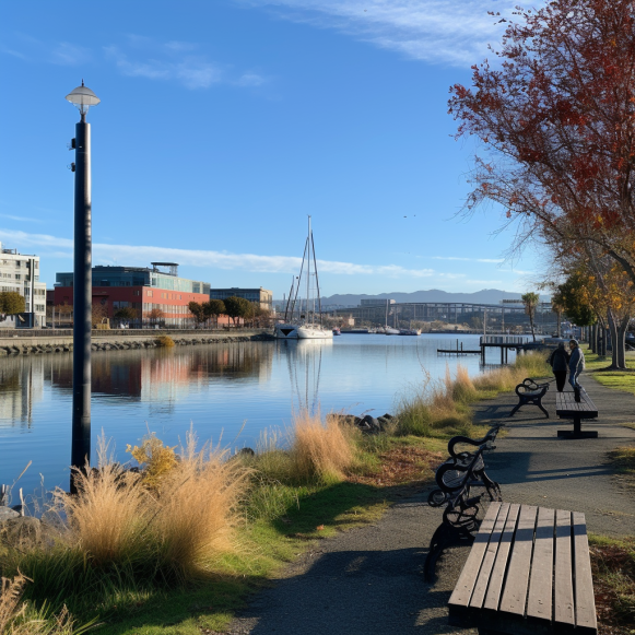
For nearly two decades, Alameda has worked to achieve what appears to be an uncontroversial goal: the construction of a pedestrian bridge across the Oakland estuary.
However, since its inception, the project has faced funding, cost, and location concerns. And now, as city staff prepares to present an update to the City Council next week, the bridge faces a new, unexpected foe: the recreational boating community, which is concerned that the bridge will effectively lock them in the estuary.
“It’s kind of like saying, ‘We’re going to put a drawbridge on the road out of your housing development,'” Winston Bumpus, a Recreational Boaters of California board member, said. “That’s not optimal.”
While boaters are concerned about losing their freedom of movement in the estuary, bicyclist groups see the bridge as a boon for the region and a far safer connection across the waterway. The bicyclist-versus-boater debate highlights the difficulties of navigating competing interests in a densely populated region, as well as the obstacles to completing infrastructure projects as seemingly innocuous as a pedestrian bridge.
The bridge debate is also a microcosm of the larger issues confronting officials throughout the Bay Area as they attempt to connect a new era of waterfront communities to inland economic centers and each other.
The primary concern of the boating community, according to Bumpus, is the bridge’s height. A bridge over 170 feet high, or roughly the height of a 14-story building, would be required to accommodate all boat traffic in the estuary. Even large Coast Guard Cutters stationed in the estuary would be able to pass through unhindered, though city officials admit ramps leading to such a bridge would be impractical.
Instead, they’re thinking about drawbridge designs that, when lowered, would rise 30 to 70 feet above the water. Still, boaters are concerned that a drawbridge will cause serious navigational issues by creating a back-up of boats waiting for the bridge to open. The proposed bridge would provide access to the bay for a number of marinas in the estuary, including the Encinal Yacht Club.
“You can go down there with a time-lapse camera, you’ll see all the boats going in and out with a mast bigger than 30 feet,” Bumpus went on to say. “We would support other alternatives.”
Much of the Bay’s shoreline has historically been surrounded by industry. However, industrial or military waterfront areas are now being developed as mixed-use housing throughout the region. The same is true in Oakland and Alameda, where numerous developments, such as Encinal Terminals and Brooklyn Basin, are planned or under construction, with each promising to add thousands of units to the region.
“This isn’t just an Alameda and Oakland thing.” “So much of the region’s new housing and commercial development is on the waterfront,” said Emily Loper, vice president of Public Policy at the Bay Area Council, a non-profit public policy organization.
However, many of these new developments in previously undeveloped areas will necessitate the construction of infrastructure to connect them to existing services. This has created a rare situation in Oakland and Alameda where even boaters and bicyclists are competing for space.
According to city planners and transportation advocates, the bridge will help the city reduce congestion while also meeting its climate and air quality goals. It would bring people together with jobs and businesses. It would also provide an alternative route between downtown Oakland and Alameda, which currently requires people to travel miles to a bridge on the island’s east side or brave the Posey Tube, a squalid tunnel with a three-foot wide sidewalk.
The proposed bridge “is the best way to knit together the two cities,” according to Rochelle Wheeler, Alameda’s senior transportation coordinator.
Although raising the bridge to allow boats to pass through is one option, a higher bridge would be more physically challenging for walkers and cyclists, potentially limiting the number of people willing to use it. Despite the fact that bike advocates would be left on either side of the bridge waiting for boats to pass, they believe the bargain is worth it.
“Waiting isn’t always fun, but if it results in better air quality, I think we should all be on board,” said Justin Hu-Nguyen, co-executive director of People and Operations for Bike East Bay, a local bicycling nonprofit. “Everyone is giving a little bit in this project.”
City officials are confident they can find a solution that works for everyone, despite the fact that no final design or even final start and end points have been determined.
Until the bridge issue is resolved, Alameda has established a pilot water shuttle program that will ferry people across the water from Jack London Square to Bohol Immigrant Circle Park beginning this spring. The city only recently announced on Facebook that it had received the vessel, which they have dubbed Woodstock.
Some boaters who question whether the bridge is worth the trouble — whether it will attract enough bicycle and pedestrian traffic, for example — believe water taxis should be the long-term solution to the connectivity problem.
However, regardless of how successful the pilot is, Wheeler stated that the water taxi will not replace bridge plans for the time being. Bridges, she claims, are open 24 hours a day, can last a century, and do not require funding to be renewed every few years.
As a result, a decade-long debate will enter a new decade, with advocates hoping for a solution that will serve as a key connector in a future East Bay.
“We’re working in a constrained area, we’re trying to balance a lot of needs,” Wheeler told reporters. “But we want to keep moving this project forward.”


